Available September 31, 2004
The Geological Survey of Denmark and Greenland (GEUS) has been continuously carrying out interpretation of available seismic data over the Danish North Sea and are happy to make the results of mapping of the Ceneozoic sediments, including details on biostratigraphic correlation, available to the oil industry at attractive commercial terms.
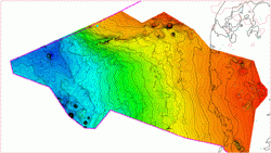
Twelve new maps of the Cenozoic succession in the Danish North Sea will be available from September 31, 2004. The maps are based on all available 2-D seismic data from the Danish North Sea and horizons are correlated with a precise, modern, and updated biostratigraphic framework from four wells. In addition, correlation between TWT seismic data and released data from all other Danish North Sea wells has been carried out. The maps divide the Cenozoic succession into major depositional units and present a very detailed mapping of the Cenozoic succession, greatly improving understanding of the Cenozoic development and the basis for exploration outside known Cenozoic production areas. Isochore maps provide a detail picture of sequences and the many Cretaceous/Paleocene channels, including the productive Siri channel.
It is believed that the package will be essential to any oil company interested in the North Sea, and may be used to:
- update knowledge on petroleum systems of the Danish North Sea area;
- reconstruct the older and deeper structural configuration of the Central Graben, improving understanding of non-structural Chalk traps;
- understand and model petroleum generation during the Cenozoic and migration to up-dip traps on adjacent highs;
- evaluate acreage to be offered in the 6 th licensing round in Denmark and acreage within the coast-near Open Door areas.
The report will be delivered in pdf-format, and all maps in addition in detailed workstation-ready xyz-format.
- 12 structural depth maps of the Cenozoic sequences from Top Cretaceous to Quaternary in TWT and depth
- 12 isochore maps
- velocity maps
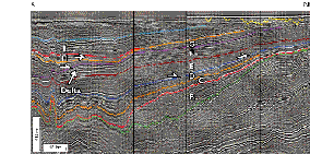
- 5 key regional seismic lines with well ties
- New biostratigraphic correlation of the Cenozoic succession
- Short report of documentation ( pdf file and hard copy)
Companies that have licensed seismic data may in addition buy the actual horizon data.
Price structure for the mapping project:
Commitment prior to August 16, 2004: 100,000.00 DDK
Commitment after August 16, 2004: 150,000.00 DKK
Price for TWT horizon data to be quoted upon request.
Data
The study is based on 11 seismic surveys: RTD-81, SP-82, DCS-81, DK1, DK2, CGD-85, NPC-85, UGCD-96, UGCDex-97, NDBT-94 and selected lines from the 3D survey in the Contiguous Area.
A new biostratigraphic study based on palynology provides the dating of seismic sequences. This study includes dating of the Cenozoic succession in the Alma-1, Frida-1, Tove-1, S-1 wells as well as more than 20 onshore boreholes and 10 outcrops. The study provides well-to-seismic ties to the C-1, E-1, Inez-1, Mona-1, R-1, Siri-1 wells as well as the afore-mentioned wells.
The maps provided in the package are:
- Top Chalk
- Top Balder Formation
- Top Eocene
- Top Oligocene
- Top Mio1
- Top Mio2
- Top Mio3 (Mid Miocene unconformity)
- Top Mio4
- Top Mio5
- Top Mio 6 (Top Miocene)
- Top Plio 1
- Top Plio 2 (Top Pliocene)
- Sea bed
For further information please contact
Senior Research Geologist Erik S. Rasmussen, Ph.D.
Geological Survey of Denmark and Greenland
Øster Voldgade 10 DK-Copenhagen K
Phone +45 3814 2504
Fax +45 3814 2050
e-mail esr@geus.dk